Shoevah to Even Sapir
Although November is almost over, Israel has not yet received any significant rainfall this autumn. Our weather concern for this hiking day was not if it would be cold and wet, but rather how hot it might be. Faced with such conditions, I decided the best segment for today’s hike on the Israel National Trail would be the ascent to Jerusalem. I hoped to enjoy the greenery and shade of the forests, and to find water in the spring-fed pools marked on the map. Since this segment is the closest the Israel Trail gets to Jerusalem, it was a natural decision to hike the trail in an “ascent to Jerusalem”. But we had plenty of descents as well.
We began our hike in Shoevah, the same place we began a hike 6 months ago. We left our cars at the gas station at the entrance to the town, and walked a few hundred meters to the start of a trail. From there it was another 1.5 kilometers until we actually connected with the Israel Trail. This time, instead of turning to the right (north direction of trail) towards Shaar Hagai, we continued straight (south direction) towards Jerusalem.
This part of the trail would not be any fun to do on a bicycle. Much too rocky!

After steady walking and taking for an hour (since leaving our cars), we reached Eyn Limon (the Lemon Spring). Still early in the morning. We had a short snack break. The air was cool and no one expressed an interest in testing the water in the pool.

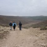
After Eyn Limon, the trail changes from a slight to a steeper incline. In my briefing at the start of the hike, I had described the entire ascent to Tzuba as a moderate climb. I understandably took some flak from the hikers when the going got a bit vigorous. As we headed up, we had lovely vistas of the forests, farmlands and villages on the surrounding hills, the outskirts of Jerusalem.

As soon as we reached Tzuba at the top of the climb, we crossed the road, and headed back down again.

As we approached Sataf, we faced a short climb. Now, this is climb that can be considered steep. Shula needed a shove from Saraleh to get going.

There were good trail blazes on this short segment. In some places, I could see three or four blazes all at once.

Cindy stops to catch her breath and pose for the camera.

Yuval kept an eye on the map the entire day. No matter how good the trail blazes are, it is always wise to keep a map in hand.

We stopped for our mid-morning sandwich and snack break at Sataf.

Vista point at Sataf.

Shula sits for a moment on an olive tree. If Miri had been with us on this hike, I think she might have been inspired to turn this pose into one of her sculptures.

Beauty spot on Sataf. The brown sign indicates the wall surrounds a garden of trees indigenous to the land of Israel. The white sign prohibits entrance.

Stone steps, stone steps, and more stone steps, lead down from Sataf. A 100-meter drop into Nahal Sorek. By the time we reached the parking lot at the bottom, some of us were keenly aware of previous injuries to our knees and ankles.

The gem of the day became apparent as we neared the end of our hike. After a short segment parallel to Highway 386, the trail turns right and crosses under the road. For the next kilometer the narrow trail climbs gradually through thick forest and across remnants of ancient stone terraces that harnessed the rain waters that flowed down this tributary of Nahal Sorek.

We were surprised by this enormous wall. It is a dam (I later learned) that was once part of an irrigation system for retaining and channeling water from nearby Eyn Hindak.

After we climbed the trail up and around the dam, the forest thinned out, and we soon arrived at Eyn Hindak. There we found no water in the pools, and lots of litter and remnant of picknickers. Yuck! Even more disturbing was the damage from a fire earlier this year (caused by carelessness) that scorched most of the hillsides from Eyn Hindak to where the trail crosses the road to Even Sapir. Despite the lack of rain, a few small wisps of green have started to rejuvenate the landscape.

We had left cars parked at the entrance to Even Sapir (starred), which gave us the option of climbing out of the trail at Eyn Hindak (3). That is what we did. That route, in fact, used to be the course of the Israel Trail.

Here’s a summary of our ascents and descents. My GPS recorded a climbing total of about 460 meters, and a hiking total of about 13 kilometers. (Click image for enlarged view. Correction: Road crossing at Tzuba is Route 3965, not 395)

P.S. We did find water at Sataf, of course. Avner took a quick dive into one of the pools before we noticed the sign prohibiting it. Here’s the incriminating evidence.
See the complete set of today’s photos (Flickr).
Click on the SLIDESHOW button for quick and easy viewing of the set.
Please use the Comment box on my blog to share your feedback with me and the other hikers and readers. Hebrew or English is welcome!
היי ליסה,
היה כייף והתמונות נהדרות, רק היה קשה שוב לעלות ולרדת את ההרים…..
ורדה
Pingback: * Good to Be Back on the Trail « ***Asterisks