Segment 27 – Moshav Ahuzam (Tel Keshet) to Pureh Nature Reserve *
After a hiatus of some ten weeks due to my recovery from retinal reattachment surgery, I was delighted to usher in New Year 2010 with a celebratory hike on the Israel National Trail.
The hike today (2 January 2010), from Tel Keshet to the Pureh Nature Reserve, was originally scheduled for early December. In retrospect, we were fortunate that the hike on this segment was postponed a month. Although flowers are not yet in blossom, the landscape now glows brilliantly green. The meadows have begun sprouting new growth and the vast expanses of recently planted wheat fields have turned velvety green.
With few significant highlights, this hiking segment can be easily summarized: Leave Moshav Ahuzam, hike across farmland, cross under Highway 40, pass the Tel Keshet mound. Continue through the wheat fields, pass a pine grove, and then stop in a eucalyptus grove. Mid-morning snack. Cross Nahal Shikma, and follow the trail as it ascends and then descends into Nahal Sahd. Rest stop. Hike along the ledge of the diminutive but lush nahal for a kilometer. Follow the trail’s new route up and down Tel Nagila. Stop at the top of the mound for an expansive vista. Cross Nahal Shikma once again and climb up to the ruins of the Turkish railroad bridge. Continue through the pine grove and into the Pureh Reserve.
Today’s hike will not be remembered for any particular point or place. Instead, I am savoring my pleasure in being back in the wilderness hiking the Israel Trail, feeling liberated and lighthearted.
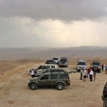
And instead of words, I’ve decided to use photos to recap the hike:
From blogs I read prior to the hike, I knew that the blazes might be missing or hard to spot in this part of the trail. As always, we were equipped with maps, which was especially wise and useful. We parked at the southern tip of the moshav, exactly where the trail passes. But we did not spot any blazes, and, eager to begin the hike, we started walking in the wrong direction. Once Yuval looked more carefully at the map, the mistake was easily corrected.
In some places the blazes are the colors of the other marked trails that the Israel Trail overlaps.
The Israel Trail route has also been altered here. Near Tel Megila, it turns onto the green trail, which goes up and down the tel and crosses over to the Turkish bridge. While it is easy to see and walk the short distance between the tel and the bridge, only a few Israel Trail blazes have been set out, and not very clearly. One blaze even points straight, when it should indicate a turn.
The Society for the Protection of Nature in Israel (SPNI) website includes a page with Israel Trail updates (Hebrew only) that do not currently appear on any trail maps. I had neglected to check the site before the hike. So I was perplexed to see the blaze indicating a turn to Tel Nagila, but pleased to discover it is no longer a detour but now part of the trail’s route.
Hat tip to my friend Hadar Heller for pointing me to the excellent Shikma Region website (Hebrew only).

Good one,Lisa. Glad that your eye is ok. Glad as well that your back on the trail. Perhaps at some point we will cross paths or walk together. Friday 29th we’re doing Tzomet Hamovil to Tivon.
I’ve actually upgraded my blog a bit with a google site
http://sites.google.com/site/theshvillers/. Check it out
Happy shvilling
Paul
Hi Paul. We were all set to do that segment (Hamovil to Tivon) in November, but I ended up in the hospital that week, and my group refused to hike without me 🙂 I’ve rescheduled that segment for April. Check our our hiking schedule on the HIKING PLAN tab at the top of my blog.