Segments 6-7 – Lower Nahal Amud to Migdal *
Only two weeks had elapsed since our last hike on the Israel National Trail. But we took to the trail again to catch the springtime greenery and blossoms before they dry and fade away for the summer. Once again it was a hot day, but the 9 hearty hikers who showed up were ready and eager for another adventure.
After leaving one car at the gas station in Migdal, we drove to the gas station at Kedarim, where we parked our other cars, enjoyed a good cup of Segafredo coffee, and then headed for the trail.
Note: I plan the hiking route and prepare the maps, which I put in Yuval’s hands. Yuval is responsible for keeping us on course since I take photos continuously during the hikes and am liable to miss a blaze or turn on the trail.
So, with Yuval leading, we bypass Kedarim junction on a 4×4 trail that is nearly hidden by waist-high wildlowers and meadowgrasses. I had intended to hook up with the Israel Trail from Highway 85, but Yuval takes us on longer route down to the trail.

Dashed pink line shows the intended “connector” route to the start of the day’s hike. The yellow line shows where we actually went.

We’re almost there. As long as we were heading downhill, no one seemed to mind the extra steps.

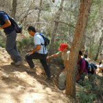
Ahh! Finally we reached Nahal Amud. Still green and lush. It was especially exciting to find spots of water. Feeling like agile youngsters, Yuval and Alon jumped across the stream. Most of us carefully stepped across the stones to reach the other side. 
Indeed, for most of us, the scenery stirred up memories of youth group hikes and high school trips. Interestingly, none of us could remember actually ever having been in this part of Nahal Amud.
The steep canyon walls.

Tall grasses and prickles of late spring. Those of us who wore long pants definitely had better wardrobe function. Fortunately it was only guys who were wearing shorts, and their non-depilated legs afforded them some protection.

The trail frequently criss-crossed the stream bed. Oleander bushes with their pink flowers decorated the trail.

We reached the “stairwell” of the National Water Carrier.

What is it about government bureaus in this country that they are incapable of getting a competent English writer to compose and/or proofread the text on public signage?

We encountered a number of these creatures along the trail. Some of them were moving quite swiftly, and made us wonder if it wasn’t the same tortoise passing us by each time.

Nearing the end of the canyon.

Just after passing the massive stone pillar that gives Nahal Amud its name, we reached the Amud spring. Cool, clear water flowing into a pond. So refreshing. A delightful surprise.

I was ready to take off my shoes and hang out here for an hour or two. But the morning was getting late, and we still had some distance to cover.

Emerging from the canyon into the Ginossar valley. More exposed to the sun and heat here, the flowers have faded and the grasses have turned brown.

Oops. We were getting tired and a bit careless. We missed the right turn where the Israel Trail breaks away from the heavily marked black trail (which continues down Nahal Amud toward the Kinneret (Sea of Galilee).
As we approached the power lines, we should have been on the lookout for the split in the trails. I promised to give half-a-kilometer credit to those who were ahead of me and had to turn around and come back (see dotted line).

Back on track. By now we were happy to have a paved track, which helped us pick up our pace.

Nearing the end of the route. Mount Arbel looms in the distance. We pondered whether we should ascend or descend it when we do that segment of the Israel Trail.

We ended our day with a delicious lunch at a Druze restaurant called Al Haruba, named for the carob tree in its front yard. The restaurant is located on a hilltop at the edge M’rar (next to Moshav Hazon), and has a stunning view of the Galilee and Kinneret. The owners of the restaurant are the two brothers of Affu (sitting at right), who is an army buddy of Ilan (second from right).

Final note: I’d promised a mostly downhill hike, and I kept my word. Our uphills totaled 236 meters, while the downhills totaled 493 meters. Both Ruthy and I logged 16 kilometers on our GPSes.
See the complete set of today’s photos (Flickr).
Click on the SLIDESHOW button for quick and easy viewing of the set.
And, please use the Comment box on my blog to share your feedback with me and the other hikers and readers.
היי ליסה,
סוף סוף מצאתי זמן לקרוא את היומן שלך. הרגשתי כאילו אני מטיילת אתכם. נראה שהיה מסלול ממש כייפי ומגוון גם במים וגם בצמחייה, חבל שפיספסתי,
נתראה בטיול הבא,
ורדה