I am pleased to present our Israel Trail Hiking Plan for 2009-2010.
This is the time to mark your calendars, and invite those friends who expressed an interest in hiking the trail, but just haven’t shown up so far.
The dates were selected to avoid conflict with orienteering league meets, mountain bike orienteering league meets, events organized by the Modiin or Rishon Lezion orienteering clubs, the Negev Championship and the annual rogaine. I also did my best to avoid setting dates that conflict with holidays, although one hike is set for Passover.
Update (5 August 2010) – What we actually hiked:
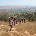
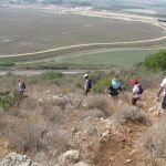
11.9 – Tel Dan to Tel Hai
12.9 – Geological Park in Kiryat Shemona to Metzudat Yesha
17.10 – Meir Sh’feya Youth Village to Bet Hanania
14.11 – hike cancelled
5.12 – hike cancelled
2.1 – Moshav Ahuzam (Tel Keshet) to Pureh Nature Reserve
6.2 – Ganei Yehoshua (Park Hayarkon), from West End to East End
6.3 – Kibbutz Dvir to Pureh Nature Reserve (south > north)
3.4 – Yesha Fortress to Nahal Dishon (Alma Bridge)
17.4 – Lower Nahal Amud to Migdal
1.5 – Sho’evah (Shoresh) to Shaar Hagai (south > north)
29.5 – Meir Sh’feya Youth Village to Kerem Maharal (south > north)
Original Plan
11.9 – Tel Dan > Tel Hai
12.9 – Tel Hai > Metzudat Yesha
17.10 – Meir Shfiya > Bet Hananya
14.11 – Alon Hagalil > Kiryat Tivon
5.12 – Tel Keshet to Shmurat Poreh
26.12 – Shaar Hagai > Shoresh (or 2.1.10)
6.2 – Tel Aviv > Hod Hasharon
27.2 – Shumrat Poreh > Dvir
3.4 – Bet Hananya > Givat Olga
17.4 – Metzudat Yesha > Nachal Dishon
7.5 – Lower Nachal Amud > Har Arbel
8.5 – Arbel > Poriah (we’ll probably reverse and go south to north)
(June) – Shoresh > Sataf
I want to give credit to a group called “Bishvil Yisrael” and their website. This is a group of people who hiked the trail, in consecutive segments, from north to south, about once a month, over a period of several years (2005-2009). During the first three years they occasionally did two hikes, on Friday and on Shabbat, staying overnight at hostels or other modest accommodations. During the last two years, about the time they reached Arad, every outing was, by necessity, a 2-day, 2-segment hike.
The organizers of this group broke down the trail into segments that are more manageable for older hikers (about 15 kilometers each, give or take a couple kilometers), and more suitable for vehicle access to start and end points. This group also hiked certain segments from south to north. Yuval and I agree this sounds like a wise idea, to avoid hefty climbing of such heights as Mount Arbel, although it has been our intention to hike every segment from north to south. Yuval and I have decided to adopt this group’s itinerary, except for the order in which we hike the segments.
Our adventures will continue ….
Pingback: Israel Trail Subtotals – Our First Season « ***Asterisks
Lisa hi
thanks for your comment on my blog. A word about the second leg. It’s long and for a large part of it on road with lots of hills, some of them quite long if not very steep.The views are pretty but road walking is a bit monotonous. The second half, when you leave the road and go by track is more interesting. The final part into then out of Nachal Kadesh is quite stunning…its like entering a secret world. We didn’t do it when we did the walk as one of us is not quite as strong a walker as the other 2 and was feeling too tired to do a strenuous last effort. I returned the following week and did just that bit…it is worth the effort.
We’re doing the Arbel this week (4th september)
best of luck
Paul
Thanks for you comment on my website, and for getting me in touch with others who are doing similar hikes to ours. I couldn’t agree more with Paul’s assessment of the Wadi Kadesh segment, it is like a fairy land tucked away out of view. But the climb is strenuous – give plenty of time to enjoy it. We were already tired when we got there and it took us about 2 hours to hike the approximately 2 kilometer, and we didn’t take anytime to just sit and enjoy.
If you visit my website you will see that I am trying to get hikers to take out more than they bring in, so that in essence every hiker leaves the trail cleaner and more beautiful than it was. We always take out our own garbage (including tissue paper) and one small extra bag of garbage we find along the trail. Think what would happen if everyone did this. Within a short time the countryside would be pristine! Perhaps your group could start doing this as well.
I forgot to leave my URL: It is http://www.DianaBarshaw.com a website about hiking the Israel Trail, Wildlife and Nature and Gardening in Israel. Hope you enjoy.
Diana
Yes, it was Paul’s comment about Nachal Kedesh that prompted us to skip the first few kilometers and begin our hike at the Geological Park. Since we’re not hiking the segments in order, we’ll return another time (and in another season) to complete the missing section. Our group made 2 rest/snack stops while in the nachal. We were so delighted with it that we were in no rush to leave. See my blog entry about that hike.
Hi Lisa,
your last leg sounds like fun. thanks for you comment on my blog. I would definitely like to do a section together…and then we’d have to write a collaborative account for our respective blogs!!
As for photos, go to my Picasa online album http://picasaweb.google.com/nirens6/Shvil1009#
unfortunately I’m auto-didactic when it come to all things related to the internet and I can’t always get my blog on the Blogger site to to what I want it to do. Any tips? I’d be happy for any advice regarding managing my blog page.
Davidi is a good friend and avid orienteerer
anyhow, we’ll stay in touch
Paul