Segment 17-18: Netanya to Gaash *
After two rather conventional Saturday morning hikes through the fields and forests of Israel, our third hike was a different sort of adventure. It was a Friday afternoon hike that took us first through the urban landscape of Netanya, and then along the seashore from Poleg to Gaash, and ended at the Hof Hasharon National Park with a night-time picnic lit by a nearly full moon and flashlights.
Friday afternoon. 4 p.m. We leave a couple cars at the Gaash beach parking lot, and head for Netanya. I have not been in Netanya for some 20 years. Downtown does not seem any different than what I remember.
16:30: We are pleased to find the designated parking lot in Netanya is empty and free of charge! Weather is lovely. We are a group of 14 today.
16:45: We get off to a somewhat delayed start, but are not concerned. We know that our first 5 km are on the Netanya promenade and city streets. The promenade is well-maintained and manicured, and dotted with all sorts of interesting environmental sculptures.

16:57 (0.65 km): We take a quick ride down and up on the seaside elevator, which carries passengers from the promenade directly onto the beach. Our very own David Aloush had a hand in its design and construction.
17:03 (1.15 km): After exiting the promenade onto a city street, we turn a corner and resume walking along a new stretch of promenade along the cliff-top. To our right is the sea; to our left are newly constructed homes and neighborhoods in development. Yuval’s foot is hurting; walking on the pavement is uncomfortable, and he needs to stop frequently. He’s holding the map, but not paying much attention to it.
17:45 (4.1 km): We continue straight on the promenade. The area is still under construction and we assume the trail markers have been obscured by it. But, in fact, we have missed a left turn.
18:00 (5.1 km): I am concerned that we have not seen a trail marker for at least a kilometer, but follow the leaders of our pack along a trail and up a hill. I get particularly concerned when I see how much trash is on the trail.
18:09 (5.7 km): We are surrounded by litter. By now, everyone realizes we are off the trail, and on top of an old garbage dump. We need to get off of it. But how? Yuval leads us down and around a path through the heart of the dump. We walk along a deep crevice of garbage bags that will never decompose. We feel like the slumdogs of Mumbai. Creepy! Funny! What a way to go off-course! Yuval gets us out of the dump by heading north through a gorge of garbage, and then east towards a stretch of open land.

18:23 (6.4 km): Ruthie and I scout ahead and find a trail marker on the main road, just a few hundred meters east of the garbage heap. We signal for everyone to follow us.
18:27 (6.7 km): We enter the Poleg Nature Reserve. We follow a sandy trail in a ravine down to the beach. We are walking intensely, but the going is rather slow in the soft sand.
18:45 (7.75 km): We pause for a short rest stop and quick snack, just before the barrier that prevents vehicle access to the beach. A massive array of litter is strewn around the barrier. Why are Israelis such slobs?!
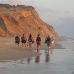
19:03 (8.0 km): We cross the barrier and greet the Mediterranean Sea. Most of us take off our hiking shoes so we can walk barefoot on the sand and tickle our toes in the water. We hike along the shoreline. Still a lot of people on the beach. Lots of noise. Lots of litter.
Eventually we get away from the public beach, and are able to enjoy the isolation and quiet of the undeveloped shoreline. This is one of the nicest parts of today’s hike, at the most beautiful time of day.

19:40 (10.8 km): The moon is starting to rise. The sun is about to set. I lag behind the group taking photos of the moon as it appears above the cliffs, and of the sun as it disappears on the horizon beyond the waves.
20:00 (11.6 km): We climb the trail up a ravine and reach the top of the cliff as darkness begins to overtake us.
20:21 (12.6 km): It is too dark to read the map, and we lose sight of the Israel Trail markers. We follow red blazes and blue blazes instead. We know we are heading in the right direction, and besides, we prefer not to descend to the shoreline should the trail head that way.
20:40 (13.8 km): We turn left at a trail junction and head toward the lights of Kibbutz Gaash. Yuval now takes charge and we follow his instructions. We cross a fence, walk along a road, then cross the fence again, heading away from the kibbutz. I’ve lost my sense of direction at this point.
20:53 (14.5 km, or somewhere thereabouts): We find an Israel Trail marker, and are now able to follow the trail. It takes us down a slope into a gulley. When we get to the bottom, we climb up the other side.
21:03 (14.9 km): We reach a wide trail, and turn right. Within moments we reach the barrier to the parking lot where the cars are parked. I’m stunned. I thought we still had a way to go. But Yuval knew almost exactly where we were. He assures me we were scarcely off course.
21:05 (15.1 km): Quick regrouping. Some off to get cars in Netanya. Some continue walking nearly another kilometer to the picnic area in the Hof Sharon Park.
21:21 (16 km): The small group that remained shared a lovely picnic dinner. We ate, drank and shmoozed until after 11 p.m. It was a most pleasurable way to lay back and relax after what had turned into quite an adventure on the trail.
The conclusions I’ve reached after this hike:
Conclusion 1: Friday afternoon is not a convenient time for many of our group members. While it seemed like a good idea a month ago, it turned out that other commitments meant we had some groups members who could not come, and others who came but were pressed to complete the route.
Conclusion 2: I prefer to hike according to the trail markers whenever possible. I certainly don’t mind wandering off course intentionally for the sake of sightseeing, but want to avoid it happening unintentionally. I’d rather go back a short distance to locate the trail, rather than forge ahead on the wrong path. Although it was rather comical, I really did not enjoy ending up in a garbage dump!
Conclusion 3: No matter how many kilometers the route is, we must expect our hikes will last at least 5 hours. Indeed they can easily take longer. As simple as it appeared on the map, it turned out that the hike took longer than anticipated, and we were walking in the dark at the end. A nighttime hike is not necessarily a bad thing, especially because we did have moonlight. But it was not what we had planned on.
Conclusion 4: I hate litter! I hate seeing all the garbage on the beach. It makes me so angry! I think I’ve stopped going to the beach because I am so annoyed by the filth that I cannot relax and enjoy the natural beauty of the seashore. Is it just me, or do other people share this feeling?

View the complete set of photos of our hike on the Israel Trail, from Netanya to Gaash.
Use the SLIDESHOW option for viewing.
Use the comment box to add your impressions from the hike, in Hebrew or English.
Hi’
As I said on the mail, it was great/
next trip will be good to change the day to Saterday, I think that in the morning It will be nicer’ less people on the beach.
BuVarda
Hi all,
Great pics, and forther more- great adventures..:-)
It can be nice on saturday morning, but, maybe starting
to walk earlier. At 10 o’clock its already hot….
all the best
lia